

[ad_1]
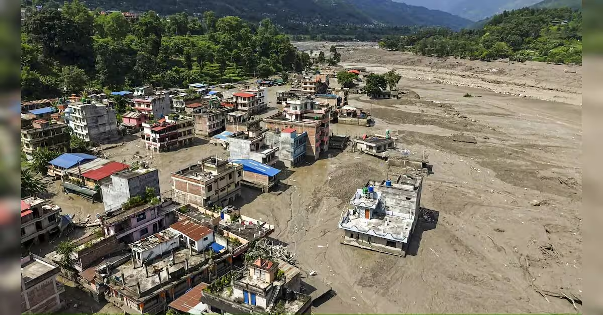
On August 26, Nepal witnessed one of the deadliest flash floods in its history. The floods hit its Himalayan region where it has caused extensive loss of life and infrastructure. The floods have left over 1,252 people killed and 4,216 remain missing, as per the latest figures compiled by country’s disaster management authority on September 3.
The disaster followed a rapid slope failure associated with a glacier collapse near Langtang Lirung, sending water, ice, rock and debris downstream through the Lhende Khola, Bhote Koshi and Trishuli river systems. The flow travelled nearly 100 km, according to the US Geological Survey.
While the immediate focus has been on deaths, missing people and the destruction of homes, roads, bridges and other infrastructure, the flood has also altered parts of the river system and surrounding landscape. The incident is also being viewed as a major ecological shock for the fragile Himalayan ecosystem.
The environmental impact can extend beyond areas directly inundated by floodwater. Prof Anjal Prakash, faculty of public policy at FLAME University, said fast-moving water carrying mud, sand and boulders can “scour riverbeds, strip streamside vegetation, undercut banks, and destroy pools, spawning grounds, and aquatic habitats”.
Why Himalayan ecosystems are vulnerable
The impact of a flood also depends on what the water carries, Prakash said. “The ecological impact, therefore, depends not only on flood depth but also on the volume, size, and composition of the debris transported,” he added.
Himalayan rivers naturally change their channels and sediment loads, but an unusually large event can exceed the ability of the river system to recover quickly.
How the flood can change rivers and habitats
A major debris flow can substantially change the physical structure of a river.
Such a flood can “substantially widen or deepen channels, breach natural banks, remove islands and vegetation, and create new bars or temporary debris dams”, Prakash said.
In steep Himalayan valleys, boulders can also force a river to change direction. “Boulders may force rivers to avulse, suddenly shift into a new course or redirect water toward settlements, farmland, and roads,” he said.
The ecological impact is not limited to the riverbank. Sediments deposited downstream can cover aquatic organisms and alter conditions in the water.
Why the risk may continue after the flood
Floodwater can leave mud, gravel and boulders on slopes, terraces and riverbanks. Prakash said these deposits can be remobilised when they are on steep or saturated ground.
“Rainfall can remobilise them as debris flows or trigger bank collapses and landslides,” he said.
Floodwater can also undercut slopes, remove vegetation and expose fractured material, reducing slope stability during the same monsoon.
Temporary debris dams are another concern. “If they fail suddenly, they can generate a second flood wave,” Prakash said.
This means risk assessments need to continue after the initial flood. Scientists should track rainfall forecasts, cracks, blocked channels, rising sediment loads and changes in river colour or discharge.
What can be said about climate change
The immediate trigger of the August 26 disaster and the broader climate conditions need to be treated separately.
The US Geological Survey has described the event as a “catastrophic debris flow” and flood likely triggered by rapid slope failure involving a glacier. It has also said it remains unclear whether the initial failure was a landslide involving part of a glacier or a glacial collapse.
Prakash said preliminary reports indicate that a glacier-related collapse and temporary river damming may have initiated the flood, but the precise contribution of rainfall, meltwater, slope geology and other factors requires field and satellite investigation.
There is, however, a broader change underway in the high mountains.
Prakash said warming is destabilising parts of the high mountains by accelerating glacier retreat, thawing permafrost, altering freeze–thaw cycles, and shifting snowfall toward rainfall.
Across Nepal’s Himalayan basins, warming is associated with glacier retreat, greater melt-season runoff in some locations and the expansion of potentially hazardous glacial lakes. A higher snowline and more precipitation falling as rain can increase rapid runoff, particularly when intense rainfall overlaps with snowmelt.
Changes in snowfall can also affect how water is stored and released. Prakash said less persistent snow may reduce delayed seasonal release, while rain-on-snow events can produce sharp floods. Thawing permafrost and loss of ice support can increase rockfall, landslide and avalanche hazards that add debris to rivers.
These changes do not affect every basin in the same way. “Risk cannot be inferred from temperature alone; local topography, geology, land use, and drainage conditions remain critical,” Prakash said.
What scientists need to monitor now
Prakash said scientists should establish repeat surveys of river channels, banks, flood deposits and damaged habitats using field measurements, drones, satellite imagery and high-resolution elevation data. They should also track suspended sediment, turbidity, water quality, channel migration, fish and benthic-organism recovery, as well as the condition of wetlands and riparian vegetation.
He said upstream monitoring should include glacier fronts, ice and rockfall, glacial lakes, moraine dams, permafrost indicators, slope cracks, rainfall, snowmelt and river discharge. “Particular attention is needed after heavy rain, when temporary debris dams or saturated deposits may fail,” he said.
“Comparing observations with pre-flood imagery and historical records will help determine whether impacts are temporary or represent a lasting shift in river structure and ecological function,” Prakash said.
Therefore, for Nepal’s Himalayan ecosystems, the environmental impact of the August 26 disaster cannot be assessed only by looking at the area covered by floodwater. The condition of river channels, sediment deposits, slopes, vegetation and freshwater habitats over the coming weeks and months will determine how much of the landscape has changed and how long those changes persist.
[ad_2]
Source link