After an encouraging start to the southwest monsoon season, India is now witnessing a prolonged pause in its advance, raising concerns over rainfall deficits, soaring temperatures and water shortages in some states.
The slowdown comes at a time when 2026 is already shaping up to be a climatically challenging year. Following months of intense heat, large parts of the country are now waiting for monsoon rains that have failed to arrive on schedule.
How has the monsoon progressed so far?
The southwest monsoon made its onset over Kerala on June 4 and advanced steadily for the next four days. It moved into parts of Karnataka and Goa along the west coast while reaching several eastern states through the Bay of Bengal branch, reported The India Express.
Kerala, southern Karnataka, Tamil Nadu, Lakshadweep and much of northeast India received good rainfall during the first week of June. Until June 10, South India recorded an 8 per cent rainfall surplus.
However, the initial burst of rainfall failed to sustain itself. In mid-June, fresh satellite imagery from the European weather satellite Meteosat, the US National Oceanic and Atmospheric Administration (NOAA) and Isro’s Insat-3DS showed a striking absence of dense cloud bands across large parts of central, western and peninsular India. These cloud formations are typically associated with an active monsoon phase.
How wide is the rainfall deficit?
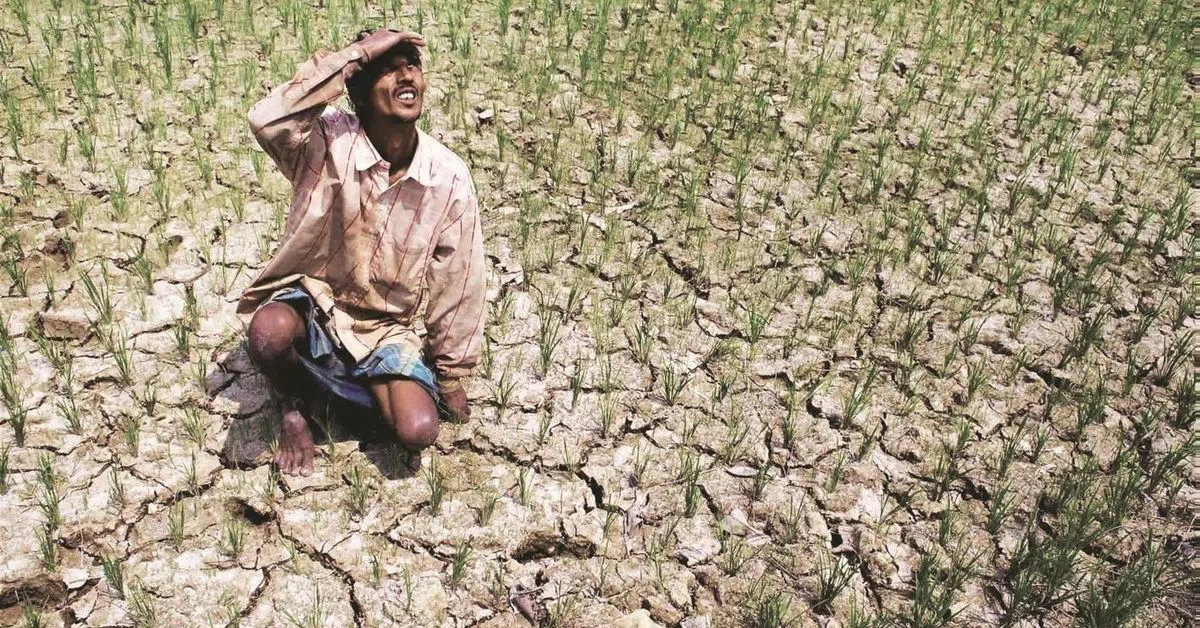
Regionally, central India has emerged as the worst-hit area. According to a Down To Earth report, India recorded a 38 percent rainfall deficit between June 1 and June 17, with central India receiving 62 per cent less rainfall than normal.
Why has the monsoon’s advance slowed?
The monsoon’s slowdown has been most visible over the Arabian Sea branch, which has struggled to push northward after making initial progress along the west coast. Large sections of Maharashtra, central India and northwest India continue to wait for sustained rainfall. According to reports, a combination of regional and global weather factors is responsible for the slowdown.
According to a Down To Earth report, one of the biggest reasons behind the stalled monsoon is the repeated intrusion of dry air into the Indian subcontinent. Throughout the first half of June, dry air penetrated western and central India, suppressing cloud formation and weakening rainfall activity. This not only disrupted monsoon circulation but also contributed to rising temperatures across several states. As a result, many areas that would normally witness widespread rain during this period have remained unusually dry.
READ | India’s monsoon starts nearly 40% below normal as El Niño disrupts weather
The situation is compounded by sluggish southwesterly winds and a weak cross-equatorial flow over the western Indian Ocean and the Arabian Sea, both are essential for sustaining the monsoon circulation, a PTI report said.
The possible emergence of El Niño conditions in the Pacific Ocean may be another reason. The IMD has previously warned that moderate-to-strong El Niño conditions may develop during the June-September monsoon season. Historically, El Niño episodes tend to weaken India’s monsoon by disrupting the large-scale atmospheric circulation that transports moisture towards the subcontinent.
Compounding the challenge is the Indian Ocean Dipole (IOD), another important climate driver. Current forecasts suggest the IOD is likely to remain neutral this season, offering little support to offset El Niño’s impact.
Adding to the challenge is the current behaviour of the Madden-Julian Oscillation (MJO), a moving band of clouds, rainfall and atmospheric circulation that travels eastward around the tropics. The MJO often acts as a trigger for enhanced rainfall over India when it enters favourable phases over the Indian Ocean. However, according to The Indian Express report the oscillation is presently positioned in an unfavourable phase, offering little support for monsoon revival.
Why is Maharashtra among the worst-affected states?
The Brihanmumbai Municipal Corporation (BMC) has already reduced water supply by 20 per cent to construction sites, commercial establishments, industries and sports clubs. The move reflects growing concerns about replenishing water stocks if rainfall remains below normal.
Although the IMD has indicated that the monsoon could reach Mumbai within the next few days, the possibility of El Niño conditions has raised fresh questions about both the intensity and distribution of rainfall during the season.
Why does a delayed monsoon matter?
The monsoon is critical to India’s economy. Nearly half of India’s agriculture activity depends on seasonal rainfall for irrigation. The country is among the world’s largest producers of rice, sugar and cotton, making monsoon performance crucial for agricultural output and rural incomes.
Poor rainfall can affect crop yields, raise food inflation risks and even trigger export restrictions on agricultural commodities. With rainfall remaining scarce across several regions, concerns are growing over water availability, electricity generation and agricultural activity in the coming months.
When is the monsoon likely to regain momentum?
There are early signs that the monsoon could begin advancing again, although uncertainty remains. According to the IMD, the monsoon is likely to progress over Telangana, Odisha, Jharkhand, Bihar and parts of Chhattisgarh over the next four to five days.
However, since June 16, the weather agency has not issued any fresh updates on monsoon advancement over Maharashtra, reflecting the uncertainty surrounding the Arabian Sea branch.
For now, meteorologists are closely watching changes in moisture flow, global weather patterns and developing El Niño conditions to determine whether the monsoon can regain strength and help ease growing concerns due to rainfall deficit.